The Polar Jet Stream
THE STRUCTURING OF MOVING FLUIDS
Fluid Salients and the Polar Jet Stream
(The Structuring of Moving Fluids) [7]
Michael A. Gorycki, Ph.D. (Revised August 19, 2018)
ABSTRACT
The literature suggests that the polar jet might be a meandering stream. Plotting a polar jet stream’s meander length and width, taken from a recently published map, on the log-log graph by Leopold and Wolman (1960), reveals that it is truly a meandering stream. Also, my stream plate observations propose that the associated atmospheric highs and lows of the jet stream are analogous to similar features that are integral to the fluid salient mechanism.
Global warming has caused an increase in sinuosity in the polar jet stream. This has led to an hypothesized reduction in its speed, often supported by the concept that straight streams flow quickly and meandering streams flow more slowly. However, due to the Coriolis effect and the conservation of angular momentum, there is an increase in the jet stream’s speed relative to the earth’s surface. This causes an increase in sinuosity (its meridional flow), which is also seen on the stream plate when the flow of water is increased. The apparent north poleward motion and reduced path of the polar jet stream may have resulted in a shift of cyclonic cold-core low pressure meander bends to more southern latitudes, and anti-cyclonic warm-core high pressure meander bends extending into higher latitudes. The result is the more chaotic and unpredictable weather that we seem to be experiencing in the U. S. at this time.
INTRODUCTION
As described in this and my other web sites,
[1] Fluid Salients and the Structuring of Moving Fluids
[2] Fluid Salients and the Formation of Beach Cusps
[3] Fluid Salients and Spiral Galaxies and Other Vortices
[4] Fluid Salients and the Formation of Round Phenomena
[5] Fluid Salients and Linear Structures
[6] Fluid Salients and Stream Meandering
[7] Fluid Salients and the Polar Jet Stream
[8] Fluid Salients and Planar Structures
a variety of natural and laboratory phenomena apparently have their origins in what I call fluid salients, a very simple mechanism that can take a variety of forms. In the web site, Fluid Salients and Stream Meandering [6], the discussion is devoted to the cause of stream meandering and associated phenomena as revealed by study of streams having a meander length of only 50 mm and a stream width of 4 mm that are produced in the laboratory on the stream plate (Gorycki, 1973). The current essay deals with the production of even smaller meanders with a meander length of 12 mm and a stream width of 1 mm. Regardless of their size, the length/width dimensional ratios of these streams fall on a graph presented by Leopold and Wolman (1960) (which I have slightly modified here) for meandering streams on glacial ice, rivers and flumes, and the Gulf Stream. Current thought holds that the polar jet stream meanders, but there seems to be no proof offered in the literature that it does, and there is very little information on the length of polar jet stream meanders to stream width. Consequently, I include a measure of the meander length to stream width taken from a published map of a known polar jet stream and find that the dimensional ratio is appropriate to Leopold and Wolman’s graph.
The Jet Stream
The Polar Jet Stream: Mini- and Mega-Meanders
Previous Work
Global Warming
Jet Stream Turbulence
As an aside, it is reasonable to infer that stream channels should be measured when they are at their greatest widths. This measurement should be made during periods of maximum discharge (prior to flood plain inundation) when the dimensions of a full stream channel are determined (and eroded) by maximum current flow. A reduction in flow would produce a slightly less wide stream which would also halt further maturation of meandering.
The Jet Stream
The main jet stream (the polar jet) is located near the altitude of the tropopause. It is caused by solar heating of the atmosphere which produces the Polar, Ferrel, and Hadley circulation cells and is located at about 60º N (Fig. 1) (see Wikipedia Jet Stream).

Fig. 1. Cross section of the atmosphere in the Northern hemisphere showing the circulation cells and the location of the polar jet.
The polar jet forms because of the circulation of these cells, and flows from west to east because of the action of the Coriolis force.
Some workers ignore the similarities between the polar jet stream and streams in general, and feel that “the jet stream does not maintain a straight zonal flow from west to east but rather takes on a more serpentine look, often with dramatic dips to the south or rises to the north. There are two major reasons for these nonzonal motions: the temperature gradient between the equator and the poles and the presence of land masses on the earth’s surface.” “The presence of land masses on the earth’s otherwise watery surface modifies the distribution of temperature, because continents heat and cool at a dramatically different rate than do the oceans. The topography of the land also influences the jet stream’s location.” (see ““jet stream,” in the stratosphere?” - Scientific American) James Partain).
I submit that the jet stream is a true stream, and that its meandering is based on the fluid salient mechanism. The location of land masses and temperature distribution may have a passive effect on meander shape, but I consider that the production and maintenance of meanders is due to the development of reversing helical flow, a function of the speed of flow of the stream [6].
The Polar Jet Stream: Mini- and Mega-Meanders
Leopold and Wolman (1960) plot the relation of meander length to channel width for meanders on glacier ice, rivers, and flumes, and also for the Gulf Stream (see their curve A in Fig. 2).
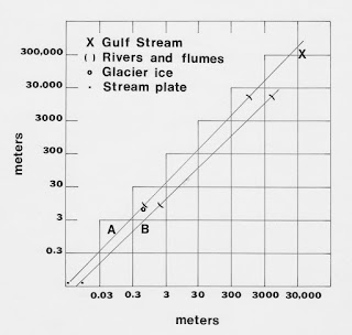
Fig. 2. Log-log graphs (after Leopold and Wolman, 1960) showing the relation of meander length (ordinate) to channel width (A), and mean radius of curvature (B). Inclusion of early stream plate data (Gorycki, 1973) extends the graph down 2.2 orders of magnitude from meanders on glacial ice.
Meandering streams produced on the stream plate (Gorycki, 1973) (using a nozzle having an inner diameter of about 2.5 mm) measure about 50 mm for the meander length, and a width of 4 mm. This value has been added to Leopold and Wolman’s graph and plot on curve A. They extend the graph downward by 2.2 orders of magnitude from meanders on glacial ice (see Fig. 2).
Ackers (1970) has related meander length to discharge. “Field data from many sources are also analyzed, on the basis of mean discharge, average flow in the month of maximum flow, mean annual flood, and bank-full discharge. This tends to confirm bank-full flow as the condition which generates the characteristic meander length.”
Recalling childhood memories of small curves formed by hot water on a smooth (hydrophobic), vertical sink surface, I recently produced meanders on the stream plate which have a meander length of about 12 mm and a stream width of about 1 mm. These smaller meanders are produced by using; 1) water heated to near the boiling point to decrease its viscosity and surface tension, 2) a number 17 hypodermic needle as a nozzle (having a right cylindrical tip with an inner diameter of 1 mm) to decrease the stream width, 3) a vertical stream plate surface to increase flow velocity, and 4) a lightly greased surface to increase its hydrophobic quality (which helps maintain the narrow stream width of the heated water). The graph of stream plate meander length to channel width can therefore be extended downward another half order of magnitude (Fig. 3).

Fig. 3. Graph by Davies and Sutherland (1980) similar to Fig. 2 but with recent stream plate work that extends point (2) downward to point (1) by 0.46 orders of magnitude. Included also is a plot of the polar jet stream (8) which also extends the graph upwards by 1 order of magnitude from the Gulf Stream (7). This gives an added total of 3.7 orders of magnitude for both of the stream plate and the polar jet stream measurements combined on Leopold and Wolman’s 1960 graph. The total for stream plate measurements and the polar jet stream increases Leopold and Wolman’s 1960 graph from 4.7 to 8.5 orders of magnitude. The Gulf Stream’s plot will be discussed shortly. Later work by Davies and Sutherland exhibits data by Zeller. These are also shown in Fig. 3 plots: 1, recent, hot water stream plate meanders; 2, early stream plate meanders; 3, solution channels in limestone; 4, expanded plot of supraglacial melt-water channels; 5, model density currents; 6, rivers and flumes; 7, Gulf Stream; 8, polar jet stream.
It is significant that the controlling factor in the stream plate system is the discharge and the nozzle diameter. They produce the narrow stream that, in turn, controls the meander length. In nature, only the channel runoff or discharge of a stream would control its width and, consequently, its meander length.
As an aside, Ackers (1970) has shown that stream channels should be measured when they are at their greatest widths. This measurement should be made during periods of maximum discharge (prior to flood plain inundation) when the dimensions of a full stream channel are determined (and eroded) by maximum current flow. A reduction in flow would produce a slightly less wide stream which would also halt further maturation of meandering.
Leopold and Wolman’s graph also includes a curve (B) showing meander length versus mean radius of curvature. However, I feel that this curve can be disregarded because I have shown that the curve within a meander bend is often not uniform. (see Gorycki, (1973), and Fig. 10 in [6].
The polar jet stream is often described as meandering (Schumm, 1985). It forms near the boundaries of air masses that are significantly different in temperature. The Coriolis Effect acts on the warm air directing it to the right (east) and helps form the polar jet which produces the major weather changes, acting in the winter, over North America.
I offer the following as proof that the jet stream is a true stream and a product of the fluid salient mechanism. A polar jet stream's structure can develop from sinuous to meandering, and meander loops can become so well developed that they can separate from the polar jet stream to produce cut-off lows or “drops” of cold air. These lows are analogous to oxbow lakes produced when cutoffs separate meander bends from a terrestrial stream during times of flood (see Wikipedia “Jet stream”, first image). Observing ink filaments in stream plate meanders, it is obvious that the highs and lows associated with the polar jet stream are part of the fluid salient mechanism and are structurally similar in location and rotation to the retarded/reversed flow of the meandering stream. Also, published maps of polar jet streams look very much like air photos of river meanders or those produced on the stream plate (Fig. 4).

Fig. 4. Map from which the polar jet stream’s meander length and width were taken to locate point 8 of Fig. 3.
A single meander length and width of a polar jet stream where taken from Fig. 4 and transferred and plotted on a globe of the world. They were then measured using the globe’s scale so that the distances would be correct. The measured length of the meander running SW of the Aleutian Islands to the Dakotas was 6,089,758 meters. The width over Saskatchewan was determined to be 722,595 meters. These were plotted on Fig. 3. Both the meander length and width fell exactly of the graph of Fig. 3 at point 8. Also, see NASA Jet Stream Animation-YouTube
This jet stream measure, compared with that of the stream plate gives a range of meander lengths of from 12 mm to 6,089,758 meters, or 1:507,396,500. I feel that the plot of point 8 in Fig. 3 offers proof that the jet stream is a true meandering stream with possibly all the characteristics that that phenomenon exhibits.
Using a log-log plot, the polar jet stream and all other stream data fall on a straight line (Fig. 3) but only if the line on Leopold and Wolman's original (1960) graph is first rotated two degrees clockwise to 44˚ from the horizontal when compared to (Fig. 2). This slightly altered slope not only also includes the very small stream plate streams, but also allows Zeller's (1967) supraglacial melt-water channels to now fall directly on the same line. The Gulf Stream plot of Davies and Sutherland also matches the plot.
Previous Work
As mentioned previously, the result of work presented here in Fig. 3, Leopold and Wolman's original graph (1960) is now extended in toto by a total of 3.8 orders of magnitude for all stream plate meanders and my polar jet stream measurements. Also included is later work by Davies and Sutherland (1980) and a similar plot of data from work done by Zeller (1967). Contained in the figure are solution channels in limestone (range 3), an expanded plot of supraglacial melt-water channels (range 4), model density currents (range 5), rivers and flumes (range 6), and the Gulf Stream (7). The hot water micro-meanders on the stream plate (point 1), and my polar jet stream calculation (point 8), increases the extent of the graph to 8.5 orders of magnitude. It also recognizes the polar jet stream as a true meander. Therefore, all are streams, regardless of fluid or substrate.
Rhoads and Welford (1991) suggest that, “the analogy between surface-tension (stream plate) streams and natural rivers must be seriously questioned because of the extreme differences in scale.” (see [6]). In the current essay I present a channel width for stream plate meanders to jet stream meanders ranging from 0.8 mm to 722,595,000 mm, and a log-log plot of meander lengths of 12 mm and approximately 6,089,758,000 mm. This is an extreme difference in scale, and yet all of the plots, including those for all stream plate streams, natural streams, the Gulf Stream (already discussed), and the polar jet stream cluster near a straight line! Add to this the fact that straight, sinuous, meandering, and braided streams can be produced in sequence on the stream plate, including meandering thalwegs and riffle and pool sequences (Gorycki, 1973). Other features on the stream plate strongly suggest they are, in fact, true streams. Ink filaments reveal a meandering thalweg morphing into reversing helical flow, which is present throughout the stream’s length. Ink filaments also reveal reverse whorls which are another feature of natural streams reported by Blue, Herbert and Lancefield (1934) [6] (and see below). They reveal the locations of point bars (due to a local diminishing of flow) and are also reproduced faithfully, as in nature, by the addition of silicon carbide sediment upstream.
Interestingly, anticyclonic lows and cyclonic highs are associated with ridges and troughs coupled with the polar jet stream. An example of their locations and directions of rotation are shown (Fig. 5).

Fig. 5. Anticyclones and cyclones associated with baroclinic waves produced by polar jet stream. Note, the anticyclone is on the south side of the polar jet stream, and the cyclone is on the north, but both are created by the shearing effect of the polar jet stream and modified by the warm and cold air on either side of it. Areas of positive vorticity advection (PVA) cause air to rise, and aid in severe weather development. Areas of negative vorticity advection (NVA) cause air to sink, inhibiting development of severe weather. On the stream plate, they are regions of retarded-reversed flow produced during the development of fluid salients. The overall easterly motion shown by the polar jet stream matches that of maturing meanders migrating downcurrent on the stream plate.
While cyclonic and anticyclonic behavior associated with the polar jet stream may not be readily apparent on the stream plate, I suggest that it can be made evident in the following manner, and also enhance the concept of the fluid salient mechanism. If silicon carbide granules (sediment) are added to meandering streams on the stream plate, they accumulate as point bars on the stream plate surface (see Point Bars in [6]). These are located where whorls of retarded-reversed flow (Blue, Herbert and Lancefield, 1934) as shown by filaments of injected ink (see also ink whirls or ink slugs, Figs. 15-18 in [6]). The whorls (cells) rotate counterclockwise (cyclonic) on the north side of the stream (water flowing to the right (east)) and clockwise (anticyclonic) on the south side, and are the result of shearing. They have the same location and direction of rotation as the cold cyclonic lows (troughs) and warm anticyclonic highs (ridges) associated with the polar jet stream (Fig. 5). Their analogues on the stream plate suggest that they form in conjunction with the polar jet stream. In a previously mentioned analogy [6], the fluid salient mechanism for beach cusps has zones of retarded-reversed flow present on both sides of each fluid salient in the ratio of 1/1, but there an elongate wave is approaching (and moving at right angles to) a beach face, not a stream flowing down a stream valley, or as a jet in the atmosphere. The cyclonic and anticyclonic structures associated with the polar jet stream, therefore, also seem to be zones of retarded-reversed flow. This suggests that the polar jet stream’s form (Rossby waves) might be based on the same dynamic structuring as seen in meanders examined on the stream plate, and is caused by the fluid salient mechanism. Of importance is the fact that these highs and lows are part of the meandering process.
Also, the fastest-moving portion of the stream of water (as shown by injected ink filaments) is in the central region, well above the stream plate surface. Consequently, using water and injected ink, the polar jet stream and associated structures appear to be reproducible on the stream plate. It would seem, therefore, that the sinuous-to-meandering process is essentially a function of axial extension (see Figs. 1-5,[6]) brought about by an increase in flow both on the stream plate and in the polar jet stream (see below).
An older explanation for the jet stream’s developing meander pattern has it that polar air pushes south and tropical air moves north as waves form in an initially slightly sinuous upper air at high latitudes so that “great tongues of air form an interlocking pattern, with the jet stream taking a sinuous path between them” (Strahler, page 247, (1971). This explanation suggests that it is the active motion of the tongues of air that are responsible for the development of the meandering rather than their passive creation (along with the formation of the highs and lows (the retarded-reversed zones)) of the fluid salient mechanism.
Global Warming
Global warming is a problem for us all. “It is likely that circulation features have moved poleward since the 1970s, involving a widening of the tropical belt, a poleward shift of storm tracks and jet streams, and a contraction of the northern polar vortex. Evidence is more robust for the Northern Hemisphere.” <A>
Current thought holds that as a result of this warming, and its northward shift, the polar jet stream is slowed and becomes more sinuous as it goes from zonal to meridional flow. An analogy with stream flow is often made in that straight streams are considered to flow quickly and meandering streams more slowly. However, disparate streams of differing sizes and rate of flow are being compared here. I’ve shown that on the stream plate an increase in flow leads to an increase in sinuosity from straight, to sinuous, to meandering, to unstable (braided), and that highs and lows are generated from retarded/reversed flows (see Figs. 1-5 and Retarded/Reversed Flow in [6]). That is, the highs and lows are caused by a vigorous flow, and not by a wobbling of a weakened polar jet stream (Fig. 6). If there is global warming it would seem that there would be an increase in the speed of the polar jet stream.

FIG. 6. Diagram in conflict with observations of meandering (polar jet) stream produced on the stream plate (Gorycki, 1973).
I suggest that due to its shortened course during its poleward migration the available energy of the polar jet stream flow is expended on an increase in sinuosity and the formation of the meanders. Also, referring to the jet stream’s northward shift, the “Earth below the air, however, moves slower as that air travels toward the poles. The result is that the air moves faster and faster in an easterly direction (relative to the Earth’s surface below) the farther it moves from the equator.” <B>
That is, the Jet stream itself may be slowed as it moves toward the northern polar vortex, but is actually moving more quickly, relative to the Earth’s surface, at these higher latitudes due to the Coriolis effect and the conservation of angular momentum. Also, the variable shape of the polar jet stream, suggested by the faster flow, is similar to the braided stream (see Fig. 5, [6]), which is unhindered by hydrophobic banks as seen on the stream plate, and driven by global warming.
Also, maturation of meander flow in the north-migrating jet stream is sometimes evidenced by the afore mentioned oxbow-like cutoffs which are similar to the production of oxbow lakes in well-developed meandering streams, as well as the formation of paired flows, similar to those in braided streams. Both morphologies suggest late-stage dynamic instability in increased jet stream flow.
There would also be an increase in overrolling at the meander bends, and a more intense retarded-reversed flow (the anticyclonic and cyclonic vortices in Fig. 5) all of which are seen on the stream plate for a meandering stream. These zones of retarded-reversed flow appear as cold lows and warm highs within baroclinic waves which are produced by the sinuous jet stream. To accommodate this “poleward shift” and the wavier configuration of the polar jet stream, equilibrium would be established between speed and sinuosity. As a result of the induced sinuosity, cyclonic, cold-core low pressure meander bends of the polar jet stream would extend into lower latitudes, and anti-cyclonic warm-core high pressure meander bends could extend into the higher (see Fig. 5). This sinuosity leads to mid-latitude temperature fluctuations, faster winds at the earth’s surface, blizzards, and increased tornado activity. This increased sinuosity is leading to the more chaotic and unpredictable weather that we seem to be experiencing in the U. S. recently (see Polar Vortex at Wikipedia).
Jet Stream Turbulence
As mentioned in [8] Clear-Air Turbulence, I consider clear air turbulence and wind shear, including downdrafts (air pockets), to be the result of the formation of fluid salients. Overrolling and the shear produced by the jet stream may produce problems in plane travel since air liners often fly at an altitude that makes use of the jet stream’s energy. This danger can only become more intense as global warming, sinuosity of the jet stream, and air travel increase. In addition, fluid salients operating at ground level at airports might be responsible for the “microbursts” that are held responsible for difficult take-offs and landings.
CONCLUSIONS
The polar jet stream exhibits many aspects associated with natural rivers and it appears to truly meander. It affords proof that it is the result of the fluid salient mechanism and demonstrates some aspects of meteorology such as the anticyclonic lows and cyclonic highs associated with polar jet stream’s ridges and troughs. Much of this can be demonstrated on the stream plate.
Questions, comments and criticism are welcomed and may be addressed to me at: Gorycki@yahoo.com
REFERENCES
Ackers, P. 1970, Meander Geometry arising from Varying Flows: Jour. of Hydrology, v. 11. p. 230-252.
Blue, F. L., jr., Herbert, J. K., and Lancefield, R. L., 1934, Flow Around a River Bend Investigated: Civil Engineering 4: 258
Davies, T. R., and Sutherland, A. J., 1980, Resistance to Flow Past Deformable Boundaries: Earth Surface Processes, v. 5, p. 175-179.
Gorycki, M. A., 1973, Hydraulic Drag: A Meander-Initiating Mechanism: Geol. Soc. America Bull., v. 84, p. 175-186.
Leopold, L. B., and Wolman M. G., 1960, River Meanders: Geol. Soc. Amer. Bull., v. 71, p. 769-794.
Rhoads, B. L., and Welford M. R., 1991, Initiation of River Meandering: Progress in Physical Geography, 15, 2, p. 127-156.
Schumm, S. A., 1985, Patterns of Alluvial Rivers: Ann. Rev. Earth Planet Sci. v. 13, p. 5-27.
Strahler, A. N., 1971, The Earth Sciences, 2nd ed., Harper and Row, New York, pp. 824.
Zeller, J., 1967, Meandering Channels in Switzerland, IUGG/IASH, Symposium on River Morphology, Bern Switzerland, p. 174-186.


Comments
Post a Comment